What Are Map Skills?
Taught in US schools

Key Takeaways
- Key map tools include the compass rose (showing directions), map key/legend (explaining symbols), and scale (converting map distance to real distance).
- Latitude lines run east-west and measure distance from the equator; longitude lines run north-south and measure distance from the prime meridian.
- Different types of maps show different information: political maps show countries and borders, physical maps show landforms, and thematic maps show specific data like climate or population.
What Are Map Skills?
Map skills are the abilities needed to read, interpret, and use maps. Maps are tools that represent the world (or part of it) on a flat surface. Learning map skills helps students understand geography, find their way around, and see connections between people, places, and events.
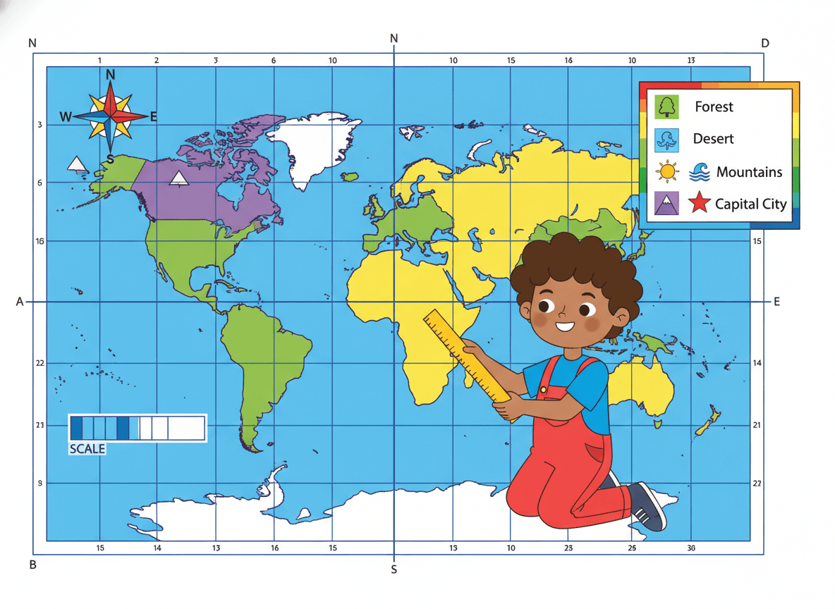
Key Map Features
Compass Rose
The compass rose shows direction on a map. It has four cardinal directions: North, South, East, West. Most compass roses also show four intermediate (or ordinal) directions: Northeast, Southeast, Southwest, Northwest.
Memory trick: "Never Eat Soggy Waffles" = North, East, South, West (clockwise)
Map Key (Legend)
The map key (or legend) explains what the symbols, colors, and lines on a map mean. Without the key, many map elements would be confusing.
Star or dot: Capital city or city
Blue area/line: Water (ocean, lake, river)
Green area: Forest or park
Brown lines: Elevation contour lines
Red lines: Highways or borders
Map Scale
A map scale shows the relationship between distance on the map and real distance on Earth. A typical scale might read: "1 inch = 100 miles." Using the scale, students can estimate actual distances between places.
Title
Every map should have a title that tells you what the map shows - "Map of the United States" or "Rainfall in North America."
Latitude and Longitude
Latitude and longitude are imaginary grid lines on Earth used to pinpoint exact locations.
-
Latitude lines (parallels) run east-west and measure distance north or south of the equator (0°).
-
Longitude lines (meridians) run north-south and measure distance east or west of the prime meridian (0°), which runs through Greenwich, England.
Together, a latitude-longitude pair gives the exact address of any point on Earth.
New York City is approximately 40°N, 74°W.
Types of Maps
Political: Countries, states, capitals, borders - Identify where countries are
Physical: Mountains, rivers, deserts, plains - Understand landforms
Thematic: One specific topic - Climate zones, population, rainfall
Road map: Roads, highways, cities - Navigate from place to place
Historical: Borders at a specific time in history - Understand how borders changed
Globe vs. Flat Map
Accurate shapes and sizes: Distorts size and shape
3-dimensional: 2-dimensional
Hard to carry: Easy to carry and print
Shows whole Earth at once: Shows regions or country
Grade-by-Grade Breakdown
K–1: Cardinal directions; simple classroom/neighborhood maps
2nd: Map key/legend; state and country maps
3rd: Scale; latitude/longitude introduction; US regions
4th–5th: Latitude/longitude coordinates; thematic maps; hemispheres
Practice Activities
-
Cardinal directions game: Students follow direction commands ("take 3 steps north, 2 steps east") around the classroom.
-
Treasure map: Students draw their own treasure map with a compass rose, key, and scale.
-
World map labeling: Label continents, oceans, equator, prime meridian, and key countries.
-
Latitude/longitude coordinates: Students find cities using coordinates and plot their school's location.
-
Map type comparison: Show the same region on a political, physical, and thematic map; discuss how each shows different information.
Frequently Asked Questions
What is a compass rose?
A compass rose is a symbol on a map showing the four cardinal directions: North (N), South (S), East (E), and West (W). It often also shows four intermediate directions: Northeast (NE), Southeast (SE), Southwest (SW), and Northwest (NW). It helps map readers orient themselves and understand which direction places are relative to each other.
What is a map key or legend?
A map key (also called a legend) explains the symbols, colors, and lines used on a map. For example, a blue line might mean a river, a red line a highway, and a star a capital city. Without the key, you cannot fully understand what the map is showing.
What is the difference between a globe and a flat map?
A globe is a three-dimensional, accurate model of Earth. A flat map is a two-dimensional representation, which always distorts the true size and shape of continents because Earth is round and maps are flat. Flat maps are more convenient but less accurate than globes, especially near the poles.
Free Map Skills Worksheets
Curriculum-aligned printable worksheets for Kindergarten – 5th Grade. Download free.


